State Map Shows Landslide Potential in Blair Park
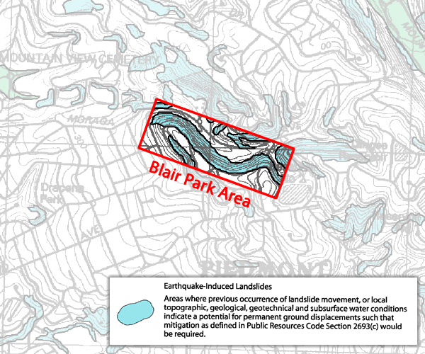
A 2003 map of the State of California Seismic Hazard Zones covering East Oakland, which includes Piedmont, shows areas prone to liquefaction or landslides. As shown on the map below, parts of Blair Park are specifically indicated in blue as a potential landslide area.
The City Council and Commissions have paid much attention to Moraga Avenue traffic safety, but less attention to potential landslides in Blair Park. Recent heavy rains have caused landslides in a number of Bay Area cities. Homes have been evacuated and cordoned off, and the potential for landslides on California hillsides has been in the headlines. The enormous earthquakes off the coast of Japan have aroused further interest in potential earthquakes in Piedmont, particularly Blair Park which is located 2700 feet west of the Hayward Fault.
After voting 4-1 on March 21 to move ahead with the Piedmont Recreation Facilities Organization (PRFO) plan to develop sports fields in Blair Park, the City Council delayed a final vote until City staff and PRFO consultants provided more information, primarily on a newly proposed concept by PRFO to install a pedestrian-operated light and crosswalk on Moraga Ave. (Although this idea was mentioned in the project Environmental Impact Report, it has never been studied by PRFO or the City.) The Council also asked for more information on legal indemnification of the City from potential lawsuits, detailed project plans and drawings which have not been made available previously, and other information.
One important issue requiring further study is the geological condition of the Blair Park hillside. Thorough and accurate geological data is imperative to safeguard everyone using the park, as well as the Moraga Avenue roadway and the homes directly above the Park, both during and after construction. To date, soil testing of the development area has been done on a limited basis. The Council has not specified if further geological information would be obtained and presented. Risk assessments for these hazards have not been provided.
Piedmonters are keenly aware of the expensive problem caused by lack of geological testing prior to the City-approved contract for the Piedmont Hills undergrounding district. Piedmont taxpayers were stuck with a bill of over $2.2 million when extensive bedrock was discovered in the construction area, despite the fact that USGS maps showing rock in the excavation area were available when the construction contract was developed and signed, yet were not consulted.
Given the great concern for children’s safety in Piedmont, as illustrated by a voter-approved seismic safety bond to retrofit and rebuild school buildings, geological conditions in Blair Park must be a primary concern. Will all relevant geological evaluations and risk assessments be thoroughly examined prior to approval of any project to ensure the project will not become a landslide disaster?
Below is a larger map illustrating where Blair Park is relative to the designated areas for potential landslides.
Map Details: Shaded in blue is the hillside surrounding and a part of the proposed Blair Park sports facility. The proposal requires cutting into the hillside, removing the toe of the hill, and constructing a 35- foot high retaining wall. Homes are built directly on top of the blue shaded landslide designated area. The Moraga Avenue roadway, as well as a portion of the area where the sports facility will be built, are shown in white and are currently considered stable land. To see the entire map of the area go to the following link.
http://geology.about.com/library/bl/maps/n_map_oakeastliqmap.htm


It looks like the worst area is the Oakland part at the top of Moraga Canyon. Better get those houses between Harbord and Estates out of the canyon now!!
If you look at the large map you’ll notice that much of the Montclair area contains much more landslide potential (blue areas). You have to weight risks and probablity. In an earthquake, I’d rather my kids be on an open soccer field than in one of those houses on the hillside.
Montclair does contain more “blue” area but as a percentage of total area, Blair Park appears to have a significantly greater percentage of landslide potential than Montclair or any surrounding neighborhood and certainly more than any Piedmont neighborhood. Maybe playing in the canyon in not the safest place for kids!
In truth, Piedmont children would be safer on the open field than in the households during an earthquake but people (and children) spend the majority of their days indoors so “living” on the soccer field is not really an option. The odds are that most people will be indoors when the earthquake comes so the likelihood that children will be protected by being on a soccer field is highly remote.
The issue that this map brings to light is not safety from landslide but the liability the city takes on by developing this facility in a landslide zone. That liability extends to the homes above Blair Park as well as the city’s own insurance on the facility. I don’t recall the EIR addressing hillside destabilization as a result of construction of the retaining wall. Obviously, the alternative options that require less hillside excavation and tiebacks reduce the city’s liability from hillside destabilization.